(Quantities can be adjusted after adding the
reproduction purchase to the cart.)
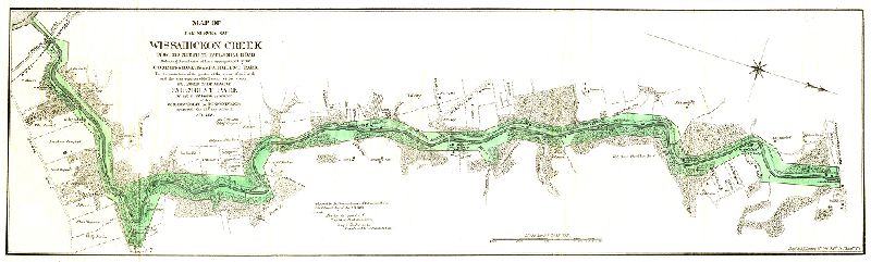
Map, Map of the survey of Wissahickon Creek from its mouth to Paul’s Mill Road defining the boundaries of land appropriated by the Commissioners of Fairmount park for the protection of the purity of the water of said creek and the preservation of the beauty of its scenery. Declared to be a part of Fairmount park by act of General Assembly of the Commonwealth of Pennsylvania approved the 14th day of April A.D. 1868.
Original size: 0 x 0 in. (estimated)
Original size: When you select "original size,"
we will reproduce the item at its actual size, which may be slightly smaller
or larger than the size shown.
Processing time: Orders generally are processed and shipped
within 2 business days. Depending on the availability of materials and staff,
it may take up to 10 business days to complete your order.
Shipping: First-class U.S. Mail shipping is included in the
listed prices. Expedited shipping may be available by arrangement.
No Permission to Publish: The purchase of a reproduction does not grant
the right to further reproduce or publish the material. For information on
obtaining permission to publish, please contact Jim Carroll (see below).
Contact: For information on turnaround times, availability of expedited processing,
and alternative shipping, please contact Jim Carroll at the Athenaeum of Philadelphia, by
e-mail at jac at philaathenaeum.org or by phone at (215) 925-2688.