
Philadelphia Streets Department Surveys
2755 result(s). Showing results 1651 to 1700.
View page: 1 2 3 4 5 6 7 8 9 10 11 12 13 14 15 16 17 18 19 20 21 22 23 24 25 26 27 28 29 30 31 32 33 34 35 36 37 38 39 40 41 42 43 44 45 46 47 48 49 50 51 52 53 54 55 56 (Show all on one page)
| Identifer | Preview | Title | Surveyor | Date | Media / Size / Scale | Area / Map Features |
| RC-017-a |

|
Plan of the Seventeenth and Nineteenth Street Passenger Railway Extension 1870 [Approved by Board of Surveyors Nov. 21, 1870] | Albertson, William |
Mounted
|
17th and 19th Streets Passenger Railway Co.
Street Railway
|
|
| RC-017-b |
|
Plan of the proposed extension of the Seventeenth and Nineteenth Street Passenger Railway [Approved by Board of Surveyors Dec. 7, 1874] | Hibberd, Josiah; Albertson, William |
Mounted
|
17th and 19th Streets Passenger Railway Co. Bounded by 17th to 19th Sts., Norris St. to Columbia Ave.
Street Railway
|
|
| RC-017-c |

|
Plan of the proposed extension of the Seventeenth and Nineteenth Street Passenger Railway, October 1878 [Approved by Board of Surveyors Oct. 21, 1878] | Cranmer, William C. |
Mounted
1 inch = 100 feet
|
17th and 19th Streets Passenger Railway Co. Bounded by 17th to 19th Sts., Carpenter to Reed Sts.
Street Railway
|
|
| RC-018-a |

|
Plan of proposed extension of 2nd & 3rd St. RR to Bridesburg, approved May 16, '59 | Not named |
Mounted
|
Richmond Street from Allegheny Ave. to Pike St.
Street Railway
|
|
| RC-018-b |

|
Plan of extension of 2nd & 3rd Strs. Passenger Rail Way on New Market St. from Coates [Coates] St. south [Survey returned Oct. 22, 1872] | Wolf, John F. |
Mounted
|
Street railway Street railway tracks in New Market St. from Coates St. to Vine St.
Street Railway
|
|
| RC-018-c |

|
Plan and profile showing the extension of the Second and Third St. Passenger Railway from Vine St. to Chestnut St. | Shedaker, David Hudson |
Mounted
|
Street railway Street railway tracks in Front St. from Vine to Chestnut Sts.
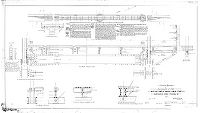
Street Railway. Detail insets include cross section of track bed; showing tie, granite block, rails and gravel; and full size section of rail, weighing "45 lbs. per yard"
|
|
| RC-018-d |
|
Plan of the Second and Third Strts. Passenger Rail Road through the 3rd Survey District [Approved by Board of Surveyors July 12, 1858] | Bonsall, Spencer; Shedaker, David Hudson |
Mounted
|
Street railway tracks on 2nd and 3rd Sts. between German and Chestnut Sts.
Street Railway
|
|
| RC-018-e |

|
Plan of proposed tracks on Richmond Street from Norris to Cumberland Sts. [Survey returned March 14, 1891; approved by Board of Surveyors March 16, 1891] | Mercer, Joseph |
Mounted
|
Street railway tracks on Richmond St. from Norris to Cumberland Sts.
Street Railway
|
|
| RC-018-f |

|
Plan and profile made for 2nd and 3rd St. Passenger R.R. Co. [Approved by Board of Surveyors May 4, 1891] | Mercer, Joseph |
Blueprint
|
Street railway tracks on 3rd St. from Dauphin St. to Indiana Ave., and on 2nd St. from Lehigh to Allegheny Aves.
Street Railway
|
|
| RC-018-g |

|
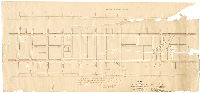
Plan showing proposed double tracks on Second Street for the extension of the Second and Third Sts. Passenger Railway from Indiana St. to Butler St., Thirty-third Ward, Phila. [Survey returned Nov. 1891] | Mercer, Joseph; Webster, John H., Jr. |
Blueprint
|
Street railway tracks on 2nd St. from Indiana St. to Butler St.
Street Railway
|
|
| RC-018-y |

|
Plan showing proposed extension of the 2nd & 3rd Sts. Passenger R.W. Co., Phila. [Ordinance March 30, 1893; approved by Board of Surveyors April 24, 1893] | Mercer, Joseph |
Blueprint
|
Street railway tracks on Cumberland St. between Kensington Ave. and Amber St.
Street Railway
|
|
| RC-018-z |

|
Plan [and profile] showing proposed arrangement of tracks on Cumberland Street for the 2nd and 3rd Sts. Passenger R.R. Co. [Survey returned April 27, 1894] | Mercer, Joseph |
Blueprint
|
Street railway tracks on Cumberland St. between Jasper St. and Amber St.
Street Railway
|
|
| RC-019-01a |
|
Plan of proposed location of track of the Southwestern Street Railway Co. on State Island Road from Penrose ferry Bridge to Bow Creek in the 27th Ward, Phil'a. [Approved by Board of Surveyors July 11, 1898. See RC-019-01b for second part of this plan.] | Gillingham, J. Harvey |
Tracing
1 inch = 50 feet
|
Southwestern Street Passenger Railway Co.
Street Railway
|
|
| RC-019-01b |

|
[No title. From RC-019-01b, the first part of this plan: "Plan of proposed location of track of the Southwestern Street Railway Co. on State Island Road from Penrose Ferry Bridge to Bow Creek in the 27th Ward, Phil'a." Approved by Board of Surveyors July 11, 1898.] | Gillingham, J. Harvey |
Tracing
1 inch = 50 feet
|
Southwestern Street Passenger Railway Co.
Street Railway
|
|
| RC-019-02 |

|
Plan of route of Southwestern St. R'w'y. from Bow Creek to Jackson St., Phila. Pa. | Damon, A. F., Jr. |
Blueprint
|
Southwestern Street Passenger Railway Co.
Street Railway
|
|
| RC-019-03 |

|
Plan of proposed location of turnouts on the State Island Road for the South Western Street Passenger Railway in the 40th Ward Phila. [Approved by Board of Surveyors April 2, 1900] | Gillingham, J. Harvey |
Tracing
1 inch = 50 feet
|
Southwestern Street Passenger Railway Co.
Street Railway
|
|
| RC-019-04 |
|
Plan for temporary location of tracks on Moyamensing and Penrose Aves from Broad St. to Penrose Ferry Bridge, 26th & 36th Wards, for Southwestern Street Railway [Approved by Board of Surveyors July 11, 1898] | Daly, Thomas |
Tracing
|
Southwestern Street Passenger Railway Co.
Street Railway
|
|
| RC-019-05 |
|
Plan with profiles locating proposed tracks of the Southwestern Passenger Railway Company in the First Ward [Approved by Board of Surveyors July 11, 1898] | Close, Charles W. |
Tracing
|
Southwestern Street Passenger Railway Co.
Street Railway
|
|
| RC-019-06 |

|
Plan and profile of Jackson Street from Fifth St. to Ostego St. showing route of the Moyamensing Ave. and Penrose Ferry Road Passenger Railway Co., First Ward, Philadelphia [Survey returned June 26, 1893; approved by Board of Surveyors Aug. 5, 1895] | Close, Charles W. |
Blueprint
|
Moyamensing Ave. and Penrose Ferry Ave. Passenger Railway Co.
Street Railway
|
|
| RC-019-07 |
|
Plan and profile of Ostego Street from Jackson St. to Mifflin St. showing route of the Moyamensing Ave. and Penrose Ferry Road Passenger Railway Co., First Ward, Philadelphia [Survey returned June 26, 1893; approved by Board of Surveyors Aug. 5, 1895] | Close, Charles W. |
Blueprint
|
Moyamensing Ave. and Penrose Ferry Ave. Passenger Railway Co.
Street Railway
|
|
| RC-019-08 |
|
Plan and profile of Moyamensing Avenue from Fifth St. to Broad St. showing route of the Moyamensing Ave. and Penrose Ferry Road Passenger Railway Co., First Ward, Philadelphia. [Survey returned June 26, 1893; approved by Board of Surveyors Aug. 5, 1895] | Close, Charles W. |
Blueprint
|
Moyamensing Ave. and Penrose Ferry Ave. Passenger Railway Co.
Street Railway
|
|
| RC-019-09 |
|
Plan showing location of temporary track on Moyamensing Ave. and Penrose Ferry Avenue Passenger Railway Co. from the west side of Broad St. to Penrose Ferry Bridge, Twenty-sixth and Thirty-sixth Wards, Philadelphia [Approved by Board of Surveyors Aug. 5, 1895] | Daly, Thomas |
Blueprint
|
Moyamensing Ave. and Penrose Ferry Ave. Passenger Railway Co.
Street Railway
|
|
| RC-019-10 |
|
Proposed sidewalk, location of tracks and reinforcement of floor - Penrose Ferry Ridge, Southwestern Street Railway Co. Plan returned Jan. 31, 1899 by Herbert A. Clarke, consulting engineer; approved by Board of Surveyors March 6, 1899] | Clarke, Herbert A. |
Tracing
|
Southwestern Street Passenger Railway Co., Penrose Ferry Bridge
Street Railway
|
|
| RC-019-11 |

|
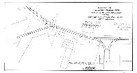
Plan of proposed location of tracks and curves of the Southwestern Street Passenger Ry. Co. over the Penrose Ferry Bridge and the southwest approach, Fortieth Ward, Philad'a. [Approved by Board of Surveyors March 6, 1899] | Gillingham, J. Harvey |
Tracing
|
Southwestern Street Passenger Railway Co.
Street Railway, building footprints including car house, hotel
|
|
| RC-019-12 |

|
Plan of proposed location of tracks, crossover and turnout of the Southwestern Street Passenger Ry. Co. on the southwest approach to the Penrose Ferry Bridge, Fortieth Ward, Philad'a. [Approved by Board of Surveyors Dec. 2, 1901] | Gillingham, J. Harvey |
Tracing
|
Southwestern Street Passenger Railway Co.
Street Railway, building footprints including car house, hotel
|
|
| RC-019-13 |

|
Plan showing proposed cross-over at Moyamensing Ave. and Porter St. fro the Southwestern Pass. Railway Co. [Approved by Board of Surveyors March 27, 1899] | Close, Charles W. |
Tracing
|
Southwestern Street Passenger Railway Co.
Street Railway
|
|
| RC-019-14 |
|
Plan of curve on State Island Road south of Penrose Ferry Bridge for the Southwestern Street Railway Co., 40th Ward, Phila. [Approved by Board of Surveyors June 5, 1899] | Gillingham, J. Harvey |
Tracing
|
Southwestern Street Passenger Railway Co.
Street Railway
|
|
| RC-019-15 |

|
Plan of tracks of Southwestern R. R. at N. approach to Penrose Bridge, 36th Ward [Approved by Board of Surveyors Feb. 20, 1899] | Daly, Thomas |
Tracing
|
Southwestern Street Passenger Railway Co.
Street Railway
|
|
| RC-019-16 |

|
Plan of tracks of Southwestern R. R. at N. approach to Penrose Bridge, 36th Ward [Approved by Board of Surveyors Dec. 2, 1901] | Nobré, John M. |
Tracing
|
Southwestern Street Passenger Railway Co.
Street Railway
|
|
| RC-019-17 |
|
Plan of the proposed change of curves of the Southwestern Street Passenger Railway Co. on State Island Road, 40th Ward Phila. [Approved by Board of Surveyors April 2, 1900] | Gillingham, J. Harvey |
Tracing
1 inch = 20 feet
|
Southwestern Street Passenger Railway Co.
Street Railway
|
|
| RC-019-18 |
|
Plan of the location of a proposed turn-out at Ninetieth Street on the line of the South-western Street Passenger Railway, 40th Ward Phila. [Approved by Board of Surveyors July 21, 1902] | Gillingham, J. Harvey |
Tracing
|
Southwestern Street Passenger Railway Co.
Street Railway
|
|
| RC-019-19 |
|
Plan of proposed turnout made for Southwestern Street Railway Co., Fortieth Ward Phila. [Approved by Board of Surveyors March 21, 1904] | Gillingham, J. Harvey |
Tracing
1 inch = 20 feet
|
Southwestern Street Passenger Railway Co.
Street Railway
|
|
| RC-019-20 |

|
Plan of proposed turnout made for Southwestern Street Railway Co., Fortieth Ward Phila. [Approved by Board of Surveyors March 21, 1904] | Gillingham, J. Harvey |
Tracing
1 inch = 20 feet
|
Southwestern Street Passenger Railway Co.
Street Railway
|
|
| RC-019-21 |
|
Plan showing proposed track turnouts on Penrose Avenue east of 25th Street, Philadelphia Railways Company, Philadelphia [Approved by Board of Surveyors May 20, 1912] | Nobré, John M. |
Tracing
|
Philadelphia Railways Company
Street Railway
|
|
| RC-019-22 |
|
Plan showing proposed cross-over on Jackson Street west of 3rd Street for the Philadelphia Railways Company, successor to the Southwestern Passenger Railway Company, Philadelphia [Approved by Board of Surveyors Feb. 5, 1912] | McFadden, R. A. |
Tracing
|
Philadelphia Railways Company
Street Railway
|
|
| RC-019-c |

|
Plan of the Navy Yard, Broad Street and Fairmount Railway Company's road on Spring Garden Street | Roberts, Edward D. |
Mounted
|
Street railway tracks on Spring Garden St. from 15th to 25th Sts.
Street Railway
|
|
| RC-020-c |
|
Plan of the extension of the tracks of the Lombard and South Streets P.R.W. and of the West End, Angora and Park P. [Passenger] R.W. [Rail Way] on Thirty-third Street from Spruce St. to Walnut St. [Survey returned March 6, 1882; approved by Board of Surveyors March 20, 1882] | Jones, William H. |
Mounted
|
Lombard and South Sts. Passenger Railway Co. Bounded by Walnut and Spruce Sts., 33rd and 34th Sts.
Street Railway
|
|
| RC-021-y |

|
Plan showing location of proposed double tracks of "The Walnut Street Connecting Passenger Railway Co. of the City of Philad'a" on Walnut Street from Twenty-second to Thirty-third St, Philadelphia [Approved by Board of Surveyors Dec. 5, 1892] | Cranmer, William C. |
Blueprint
|
Walnut Street Connecting Passenger Railway Co.
Street Railway
|
|
| RC-021-z |
|
Plan [and profile] of Chestnut Street from 31st St. to the bridge over Schuylkill River in the Twenty-seventh Ward, Philadelphia [No date] | Jones, William H. |
Mounted
1 inch = 50 feet
|
Chestnut Street, west approach to bridge over Schuylkill River
Street Railway
|
|
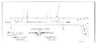
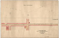
| RC-022-a detail |

|
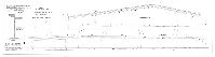
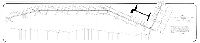
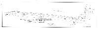
[No title. Long profile, probably of the Philadelphia and Olney Railway. Interesting topographical and infrastructure details: bridges, trestles, valley of Wingohocking Creek and other valleys. Shows what appear to be different proposed routes. Chatham St. is on the left end of plan, "Turnpike Olney" on right end. Only a small section of this very long plan was scanned.] | Not named |
Paper
|
Philadelphia and Olney Railroad
Street Railway. Interesting topographical and infrastructure details: bridges, trestles, valley of Wingohocking Creek and other valleys.
|
|
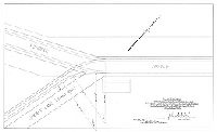
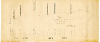
| RC-022-a1 detail |

|
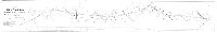
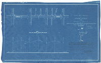
Profile, Philada. and Olney Rail Road from 6th & Lehigh Ave. to New Second St. Road and Olney Road. Strickland Kneass, Chief Eng. [ Only a small section of this plan was scanned.] | Shallcross, Isaac; Lightfoot, Jesse |
Paper
|
Philadelphia and Olney Railroad
Street Railway. Interesting topographical and infrastructure details: bridges, trestles, valley of Wingohocking Creek and other valleys.
|
|
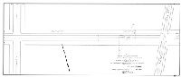
| RC-022-a2 detail |

|
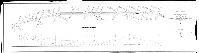
[No title. Profile, Philadelphia and Olney Railroad. Only a small section of this very long plan was scanned.] | Not named |
Paper
|
Philadelphia and Olney Railroad
Street Railway. Interesting topographical and infrastructure details: bridges, trestles, valley of Wingohocking Creek and other valleys.
|
|
| RC-022-b |

|
Plan and profile of Sixth Street from Diamond Street to Lehigh Avenue. [On reverse: "Olney Railway"; approved by Board of Surveyors April 21, 1862] | Davis, James P. |
Mounted
|
Philadelphia and Olney Railroad
Street Railway
|
|
| RC-022-c |

|
Plan and profile of the proposed line of the Philadelphia and Olney Rail Road from Lehigh Avenue to Wingohocking Creek [Approved by Board of Surveyors April 21, 1862] | Shallcross, Isaac |
Mounted
|
Philadelphia and Olney Railroad. Bounded by 5th to 6th Sts., Lehigh Ave. to Wingohocking Creek
Street Railway
|
|
| RC-022-d |

|
[No title. Vicinity of Fifth Street and Wyoming Avenue. On reverse: "Olney P. R. R. Co."] | Not named |
Mounted
|
Philadelphia and Olney Railroad (Olney Passenger Railroad Co.), vicinity of 5th St. and Wyoming Ave.
Street Railway
|
|
| RC-022-e |
|
Profile of the proposed line of the Phila. & Olney R.R., from Wingohocking [Creek] to New Second St. Road [On reverse: "Profile of Fifth St. and Wyoming Av."] | Lightfoot, Jesse |
Mounted
|
Philadelphia and Olney Railroad
Street Railway
|
|
| RC-022-y |

|
[No title. Scatchard's Dam, on Wingohocking Creek.] | Not named |
Blueprint
|
Germantown. Scatchard's Mill Dam, Wingohocking Creek
Mill dam and pond on Wingohocking Creek, with building footprint of mill
|
|
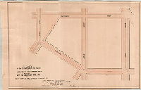
| RC-022-z |

|
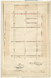
[Handwritten title on reverse: "Plan showing location of cemetery wall." Shows Haines St. from Mansfield St. to Limekiln Pike. Refers to Philadelphia National Cemetery, located at E. Haines St. and Limekiln Pike. Mansfield Street is no longer on the City Plan at this location.] | Jones, Walter |
Mounted
1 inch = 100 feet
|
Philadelphia National Cemetery
Plan locating cemetery Wall
|
|
| RC-023-b |

|
Plan of proposed extension of Empire Passenger Railway [Approved by Board of Surveyors April 17, 1876] | Hibberd, Josiah |
Mounted
|
Street railway tracks on Susquehanna Ave., Norris St. and Berks St. between 12th and 16th Sts.
Street Railway
|
|
| RC-023-c |

|
Plan of the proposed extension of tracks of the Empire or 12 and 16 Sts. Passenger Rail Road Company | Close, Charles W. |
Mounted
|
Street railway Street railway tracks on 12th St. to Dickinson St. to 16th St.
Street Railway
|