
Philadelphia Streets Department Surveys
2755 result(s). Showing results 451 to 500.
View page: 1 2 3 4 5 6 7 8 9 10 11 12 13 14 15 16 17 18 19 20 21 22 23 24 25 26 27 28 29 30 31 32 33 34 35 36 37 38 39 40 41 42 43 44 45 46 47 48 49 50 51 52 53 54 55 56 (Show all on one page)
| Identifer | Preview | Title | Surveyor | Date | Media / Size / Scale | Area / Map Features |
| 119-10 MTD |
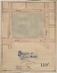
|
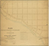
Plan of Ontario Park [Ordinance June 22, 1892; confirmed Oct. 3, 1892] | Carlile, William K. |
Mounted
|
Bounded by Ontario St., Thompson St., 13th St. and Stiles St.
Curb elevations
|
|
| 119-19 MTD |
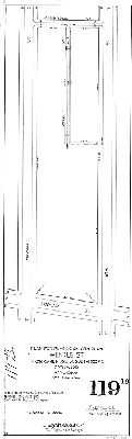
|
Plan for placing on City Plan Wendle St. from Cambridge St. south 322 ft. 20th Ward. April 17, 1905 | Carlile, William K. |
Mounted
|
Wendle St. at Cambridge St.
Curb elevations
|
|
| 119-20 MTD |
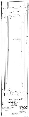
|
Plan for placing on City Plan Cambridge St., Marshall St. west to dead end. 20th Ward. April 17, 1905 | Carlile, William K. |
Mounted
|
Cambridge and Marshall Sts.
Curb elevations
|
|
| 119-21 MTD |
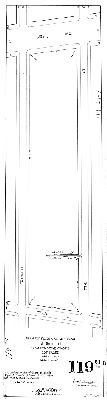
|
Plan for placing on City Plan George St. from 7th St. west 108 ft. 20th Ward. April 17, 1905. | Carlile, William K. |
Mounted
|
George St. at 7th St.
Curb elevations
|
|
| 119-22 MTD |

|
Plan of the revision of lines and grades of streets on a portion of City Plan No. 119 crossing or adjacent to the Phila. Germantown and Norristown R.R. between Poplar St. and Montgomery St. [Ordinance Oct. 13, 1906, related to grade crossing abolishment; confirmed May 13, 1907.] | Carlile, William K. |
Mounted
|
Bounded by Montgomery Ave. to Poplar St., 8th to 10th Sts.
Curb elevations
|
|
| 120 MTD |

|
Plan of the revision of the survey and regulation of the Third Section of the Seventh Survey District, Twentieth Ward, Philadelphia. | Haines, Henry |
Mounted
|
20th Ward, 7th Survey District, 3rd Section. Bounded by Montgomery Ave. to Poplar St., Broad to 23rd Sts.
Curb elevations
|
|
| 120 MTD attachment |
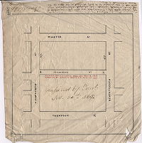
|
[No title. Ingersoll Street, confirmed Nov. 24, 1869] | Not named |
Tracing
|
Bounded by Master to Thompson Sts., 17th to 18th Sts.
Attachment
|
|
| 120-03 MTD |

|
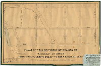
Plan of the lines and grades of Twentieth St. from Girard to South College Aves. June 6th, 1892. [Ordinance March 15, 1892; conf. Sept. 26, 1892] | Carlile, William K. |
Mounted
|
20th St. near Girard Ave.
Street lines, buildings in street
|
|
| 120-04 MTD |

|
Plan for placing on City Plan. Harper St., 19th St. to 20th St. 29th Ward. April 17, 1905. [Ordinance Feb. 13,1905 and March 30, 1906; confirmed July 2, 1906] | Carlile, William K. |
Mounted
|
Harper St. at 19th St.
Curb elevations
|
|
| 120-05 MTD |

|
Plan of lines and grades of Henrietta Street, 21st St. to North College Ave. 29th Ward. [Ordinance March 30, 1894; confirmed June 4, 1894] | Carlile, William K. |
Mounted
|
Henrietta St. at 21st St.
Curb elevations
|
|
| 120-06 MTD |

|
Plan for placing on City Plan Carlisle St. from Montgomery St. southward. 29th Ward. [Ordinance Nov. 15, 1909; confirmed March 7, 1910] | Carlile, William K. |
Mounted
|
Carlisle St. at Montgomery St.
Curb elevations
|
|
| 120-07 MTD |

|
Plan for placing on City Plan Flora St. from Carlisle St. to 15th St.. 29th Ward. April 17, 1905. [Ordinance Feb. 13, 1905; confirmed July 3, 1905] | Carlile, William K. |
Mounted
|
Carlisle St. at 15th St.
Curb elevations
|
|
| 120-08 MTD |
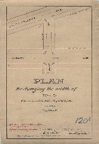
|
Plan for changing the width of 20th St., South College Ave. to Girard Ave. 29th Ward. May 28th, 1894. [Ordinance April 4, 1894; confirmed June 4, 1894] | Carlile, William K. |
Mounted
|
20th St. at Girard Ave.
Curb elevations
|
|
| 120-09 MTD |

|
Plan of the lines and grades of Harlan Street, from Eighteenth to Nineteenth Streets, in the City of Philadelphia. [Ordinance July 24, 1889; confirmed Feb. 3, 1890] | Albertson, William |
Mounted
|
Harlan St. at 18th St.
Curb elevations
|
|
| 121-03 MTD tracing |
|
Plan of the revision of the lines and grades in the Fourth Section, Seventh Survey District, Philadelphia. [Ordinance Dec. 31, 1875; confirmed Dec. 4, 1876. Tracing made in 1934] | Not named |
Tracing
|
7th Survey District, 4th Section. Bounded by Montgomery Ave., Ridge Ave., 23rd St., Poplar St., Pennsylvania Ave. and 33rd St.
Curb elevations, stream
|
|
| 121-04 MTD |

|
Plan of the revision of grades in a part of the Twenty-ninth Ward Philadelphia. [In pencil, not legible in scan: "Res. [Resolution] Feb. 2, 1872." Original elevations, in pencil, also not legible on scan.] | Not named |
Mounted
|
Bounded by Berks St., Ridge Ave., Master St. and 33rd St.
Curb elevations
|
|
| 121-46 MTD |
|
Plan of the revision of lines and grades of Oxford St. from 28th St. to Fairmount Park. [Ordinance March 18, 1891; confirmed July 6, 1891] | Carlile, William K. |
Mounted
|
Bounded by Columbia Ave. to Jefferson St., 28th to 33rd Sts.
Curb elevations, railroad
|
|
| 121-z CP |

|
Plan of the resurvey of lines and grades of City Plan No. 121, Philadelphia. [Ordinance May 25, 1904; confirmed Aug. 30. 1915] | Carlile, William K. |
Tracing
|
Bounded by Montgomery Ave. to Poplar St., 23rd St. to 33rd Street at Fairmount Park boundary
Curb elevations
|
|
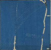
| 122-01 HP |
|
Plan of revision of the survey and regulation of the Fifth Section of the Seventh Survey District, Twentieth Ward, City of Philadelphia [Ordinances May 25, 1857 and Oct. 26, 1858; approved by Board of Surveyors Nov. 16, 1857; confirmed by Court May 18, 1863] | Haines, Henry |
Mounted
1 inch = 100 feet
|
20th Ward, 7th Survey District, 5th Section. Triangular area bounded by Schuylkill River, 33rd St., and Montgomery Ave.
Bridge at Girard Avenue, curb elevations, railroad in middle of Pennsylvania Avenue to bridge at Columbia Avenue
|
|
| 122-02 HP |
|
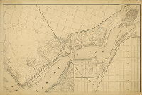
Plan of the revision of grades of Girard Avenue from Twenty-eighth Street to the Schuylkill River [Ordinance May 25, 1857; approved by Board of Surveyors Nov. 16, 1857; confirmed by Court Dec. 8, 1858. Attachment: Copy of Section 2 of ordinance "for the construction of a bridge over the Reading Railroad approved May 25 A.D. 1857"] | Kneass, Strickland |
Mounted
1 inch = 100 feet
|
Girard Ave., 28th St. to Schuylkill River
Bridge at Girard Avenue, stream penciled in, curb elevations, Attachment: Copy of ordinance ordering revision
|
|
| 122-03 HP |
|
Plan of the revision of grades and footways on Pennsylvania Avenue from Poplar Street to Columbia Avenue [Ordinance June 23, 1862; approved by Board of Surveyors Dec. 1, 1862 | Haines, Henry |
Mounted
1 inch = 100 feet
|
Pennsylvania Avenue, Poplar St. to Columbia Ave., with surrounding streets to Schuylkill River
Pennsylvania Railroad, Columbia Bridge, Girard Bridge, curb elevations
|
|
| 122-x1 HP |
|
[No title. Fairmount Park topography. Additions in pencil probably related to the route of the Philadelphia and Reading Railroad through Fairmount Park from the bridge over Fountain Green to the Columbia Bridge] | Not named |
Mounted
|
Fairmount Park. Shows both sides of the Schuylkill River from Fairmount Water Works to approximately Susquehanna St.
Lithograph. Many details of the Fairmount Park shown, including water works, bridges, houses. Modern street names added in pencil, and many other penciled additions
|
|
| 122-x2 HP |

|
[No title. Philadelphia and Reading Railway crossing Fountain Green Bridge] | Not named |
Tracing
|
Pennsylvania Railroad from Columbia Bridge to Fountain Green Bridge
Railroad tracks, bridge
|
|
| 122-x3 HP |
|
Plan showing tracks on P&RR (Philadelphia and Reading Railroad] from Fountain Green Bridge to Columbia Bridge | Not named |
Blueprint
1 inch = 50 feet
|
Pennsylvania Railroad from Columbia Bridge to Fountain Green Bridge
Railroad tracks, bridge
|
|
| 123-01 MTD |
|
Plan of the survey and regulation of the First Section of the 21st Ward between 11th and 20th Streets and Columbia and Susquehanna Avenues. [Ordinance Aug 15, 1855; survey returned August 1856; approved July 6, 1857; confirmed by Court June 11, 1860] | Siddall, Joseph S. |
Mounted
|
21st Ward, 1st Section. Bounded by 11th to 20th Sts., Columbia to Susquehanna Aves.
Curb elevations, sewers, Monument Cemetery, streams added in pencil
|
|
| 123-01 MTD tracing |

|
Plan of the survey and regulation of the First Section of the 21st Ward between 11th and 20th Streets and Columbia and Susquehanna Avenues [Ordinance Aug 15, 1855; survey returned August 1856; approved July 6, 1857; confirmed by Court June 11, 1860] | Siddall, Joseph S. |
Tracing
|
21st Ward, 1st Section. Bounded by 11th to 20th Sts., Columbia to Susquehanna Aves.
Curb elevations, sewers, Monument Cemetery
|
|
| 124-02 MTD |
|
Plan of the survey and regulation of the Second Section of the Twenty-first Ward of the City of Philadelphia [Ordinance Aug 15, 1855; survey returned Sept. 1856; approved July 6, 1857; confirmed by Court June 11, 1860] | Siddall, Joseph S. |
Mounted
|
21st Ward, 2nd Section. Bounded by Columbia to Susquehanna Aves., 20th to 30th Sts.
Glenwood Cemetery, Odd Fellows Cemetery, Mechanics Cemetery
|
|
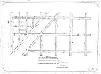
| 124-03 MTD |
|
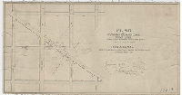
Plan of vacation of Mifflin Lane from Montgomery St. to Ridge Ave., 32[nd] Ward [Ordinance Dec. 21, 1892; confirmed April 29, 1893] | Carlile, William K. |
Paper
|
Bounded by Diamond, 30th, Montgomery and 33rd Sts.
Diagonal line of Mifflin Street cutting across grid
|
|
| 124-54 MTD |
|
Plan of revision of lines and grades on Ridge Avenue between Twenty-seventh and Twenty-ninth Streets, Twenty-eighth Ward, City of Philadelphia. [Resolution June 1, 1867; approved by Board of Surveyors June 15, 1868] | Levering, John H. |
Mounted
|
Bounded by Diamond St., 27th St., Berks St., and 30th St.
Grade elevations, calculations in pencil
|
|
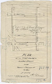
| 125-02 MTD |
|
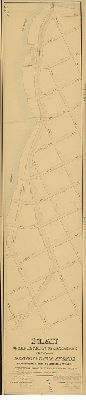
Plan of the Third Section of the survey and regulation of the Twenty-first Ward of the City of Philadelphia [Ordinance Aug. 15, 1855; approved by Board of Surveyors Sept. 21, 1857; confirmed by Court June 11, 1860] | Siddall, Joseph S. |
Mounted
|
21st Ward, 3rd Section. Germantown Ave. to 15th St., Lehigh to Susquehanna Aves.
Streams, marshland, railroad, property lines and owners, "Table of Level Benches"
|
|
| 125-04 MTD |
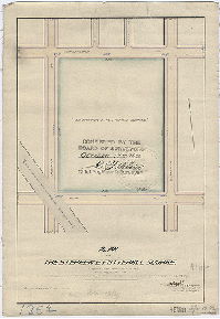
|
Plan of the Stephen E. Fotterall Square, Twenty-eighth Ward, Philadelphia. [Ordinance March 10, 1892; confirmed Oct. 17, 1892] | Fuller, H. M. |
Mounted
1 inch = 100 feet
|
Stephen E. Fotterall Square, bounded by 11th to 12th Sts., Cumberland to York Sts.
Curb elevations, railroad
|
|
| 125-06 MTD |
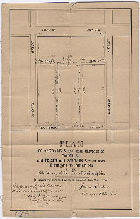
|
Plan of Oakdale Street from Eleventh to Twelfth Sts. And Jessup and Sartain Streets from Huntingdon to Oakdale Sts. In the 28th Ward of the City of Philadelphia [Ordinance June 29, 1883; confirmed Aug. 4, 1884] | Hibberd, Josiah |
Mounted
|
Bounded by Lehigh Ave. to Huntingdon St., 11th to 12th Sts.
Curb elevations
|
|
| 125-07 MTD |

|
Plan of the lines and grades of Sartain Street between Cumberland Street and Huntingdon Street in the 28th Ward of the City of Philadelphia [Ordinance Nov. 19, 1888; confirmed April 1, 1889 | Fuller, H. M. |
Mounted
|
Bounded by Huntingdon to Cumberland Sts., 11th to 12th Sts.
Curb elevations
|
|
| 125-08 MTD |
|
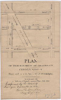
Plan of the revision of grades on Colona Street, from 10th to 11th Sts., City of Philadelphia [Ordinance March 17, 1884; confirmed Sept. 21, 1885] | Not named |
Mounted
|
Bounded by Nevada St. to Susquehanna Ave., 11th to 12th Sts.
Curb elevations, railroad
|
|
| 125-09 MTD |
|
[No title. Probably plan of Alder Street and Warnock Street. Survey returned July 15, 1872; confirmed Feb. 3, 1873] | Hibberd, Josiah |
Paper
|
Bounded by 10th to 11th Sts., York to Cumberland Sts.
Curb elevations
|
|
| 125-10 MTD |

|
Plan of Warnock and Alder Streets [Survey returned Jan. 24, 1872; confirmed Oct. 7, 1872] | Hibberd, Josiah |
Paper
|
Bounded by Cumberland to Huntingdon Sts., 11th St. to 10th St. and Germantown Ave.
Curb elevations
|
|
| 125-11 MTD |
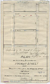
|
Plan of the lines and grades of Tucker Street from Twelfth Street to Thirteenth Street, 28th Ward Philadelphia. [Ordinance Jan. 29, 1890; confirmed May 19, 1890] | Fuller, H. M. |
Paper
|
Bounded by Lehigh Ave. to Huntingdon St., 12th to 13th Sts.
Curb elevations
|
|
| 125-12 MTD |
|
Plan of the lines and grades of Park Avenue from York to Cumberland St., Clarion St. from York to Hagert St., Hagert St. from Clarion to Thirteenth St., Emlen St. from Park Ave. to Broad St. 28th Ward Philadelphia [Ordinances June 16 and July 1, 1890; confirmed Aug. 18, 1890] | Fuller, H. M. |
Paper
|
Bounded by Cumberland to York Sts., Broad to 13th Sts.
Curb elevations
|
|
| 125-13 MTD |

|
Plan of Warnock and Kannuset Streets [Ordinance July 6, 1876; confirmed Oct. 23, 1876] | Not named |
Paper
|
Bounded by Lehigh Ave. to Huntingdon St., 11th St. to Germantown Ave.
Curb elevations
|
|
| 125-14 MTD |
|
Plan of the lines and grads of Fifth Street from Twelfth to Thirteenth St. [Ordinance March 30, 1889; confirmed May 19, 1890] | Fuller, H. M. |
Paper
|
Bounded by Cumberland to Huntingdon Sts., 12th to 13th Sts.
Curb elevations, railroad
|
|
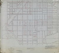
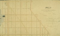
| 126-01 CP |

|
Plan of the revision of lines and grades upon a portion of the Sixth and Seventh Sections of the Twenty-eighth Ward, Philadelphia | Fuller, H. M. |
Tracing
1 inch = 100 feet
|
Bounded by Indiana to York Aves., 21st to 15th Sts.
Topography on portion of plan covering Cit Plan 28
|
|
| 126-01 MTD |
|
Plan of the Sixth Section of the survey and regulation of the Twenty-first Ward of the City of Philadelphia. [Ordinance Aug. 15, 1855; approved April 11, 1859; confirmed by Court June 20, 1859] | Siddall, Joseph S. |
Mounted
|
21st Ward, 6th Section. Susquehanna to Lehigh Aves., 15th to 30th Sts.
Streams, old roads, sewers, property lines
|
|
| 127-01 MTD blueprint |
|
Map of the revision of lines and grades with topography upon Plan 127. [Ordinance March 31, 1884; confirmed April 1, 1889; copy made 1912] | Not named |
Blueprint
|
Bounded by Erie to Lehigh Aves., 15th St. to Germantown Ave.
Topography, streams, building footprints
|
|
| 127-03 MTD |
|
Plan of the Fifth Section of the survey & regulation of the Twenty-first Ward of the City of Philadelphia [Ordinance Aug. 15, 1855; approved May 3,1858; confirmed by Court July 17, 1858] | Siddall, Joseph S. |
Mounted
|
21st Ward, 5th Section. Bounded by Erie to Lehigh Aves., 15th St. to Germantown Ave.
Streams, springs, sewers, railroad, old roads, property lines, curb elevations, table of level benches
|
|
| 128 CP |
|
Compiled Plan of City Plan No. 128, 38th Ward, Philadelphia. | Robinson, John H. |
Tracing
1 inch = 100 feet
|
Bounded by Broad St., Lehigh Ave., 29th St. and Allegheny Ave.
Curb elevations; list of all relevant ordinances to 1956, concerning revision of lines and grades, and placing streets on or striking streets from the plan
|
|
| 128-01 MTD |

|
Plan of the Seventh Section of the survey and regulation of the Twenty-first Ward of the City of Philadelphia. [Ordinance Aug. 15, 1855; approved April 11, 1859; confirmed by Court July 2, 1859] | Siddall, Joseph S. |
Mounted
|
21st Ward, 7th Section. Allegheny to Lehigh Aves., 15th to 30th Sts.
Streams, sewers, old roads, Philadelphia, Germantown and Norristown Railroad
|
|
| 128-04 MTD |
|
Plan of the revision of lines and grades of Plan No. 128, bounded by 15th St., 29th St., Lehigh Ave. and Allegheny Ave. Thirty-eighth Ward Philadelphia. [Ordinance April 8, 1897; various confirmations in 1898] | Fuller, H. M. |
Mounted
1 inch = 100 feet
|
Bounded by 15th St., 29th St., Lehigh Ave. and Allegheny Ave.
Topography, streams, ponds, building footprints, railroads, Cambria Reservoir site
|
|
| 128-05 MTD |

|
Plan of the revision of lines and grades upon the Seventh Section and a portion of the Eleventh Section of the Twenty-eighth Ward. [Ordinance Feb. 25, 1884; confirmed Feb. 1, 1886 and March 21, 1887] | Not named |
Mounted
|
28th Ward, 7th Section and part of 11th Section. Bounded by Ridge Ave. to Broad St., Lehigh to Allegheny Aves.
Topography, Cambria Reservoir Ground (never built), railroad, streams and ponds, quarries, building footprints, Mt. Vernon Cemetery
|
|
| 128-05 MTD tracing |

|
Plan of the revision of lines and grades upon the Seventh Section and a portion of the Eleventh Section of the Twenty-eighth Ward. [Ordinance Feb. 25, 1884; confirmed Feb. 1, 1886 and March 21, 1887] | Not named |
Tracing
|
28th Ward, 7th Section and part of 11th Section. Bounded by Ridge Ave. to Broad St., Lehigh to Allegheny Aves.
Topography, Cambria Reservoir Ground (never built), railroad, streams and ponds, quarries, building footprints, Mt. Vernon Cemetery
|
|
| 129-02 MTD |

|
Plan of the Eighth Section of the survey and regulation of the Twenty-first Ward of the City of Philadelphia. [Ordinance Aug. 15, 1855; confirmed by Court June 11, 1860] | Siddall, Joseph S. |
Mounted
|
21st Ward, 8th Section. Bounded by Allegheny to Erie Aves., 15th to 30th Sts.
Streams, old roads, Norristown Railroad
|